![]()
|
Forced displacement in Colombia is one of the strategies that have been adopted by the parties to the armed conflict; a strategy in which the civilian population is used for regional military, political and economic control. This is demonstrated by the concentrations of armed attacks and by the territorial expansion and geographical distribution of displacement. By definition, the phenomenon of displacement affects peasant sectors.
Colombia lacks a system of information on forced displacement that allows figures to be put on the real magnitude of this phenomenon and on the magnitude of the demand of effective assistance from the Colombian State. Estimates vary considerably, ranging from over two million people in the past fifteen years, 288,127 in 1999, according to the Advisory Office for Human Rights and Displacement -CODHES-, to some 180,000 registered in the National Register of Displaced Population from 1997 onwards, to a figure of 46,000 recorded by the Episcopal Conference's RUT system since 1996. For this reason, the national government has adopted an initiative from the UNHCR to evaluate the various methodologies of information gathering, and the criteria applied. The Social Solidarity Network draws information from two sources, namely, the population registered for state assistance -the Single Register System (SUR)-, and an estimate of the displaced population, given the fact that not all displaced persons register on the SUR system.
(1) The Displaced
Population Estimates System collects information from the territorial
committees on displacement. The SUR register collects voluntary, impromptu
statements from persons claiming state assistance, which are assessed
by the Social Solidarity Network. According to government records, people are expelled from
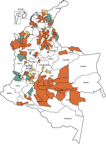
a total of 763 municipalities; 414 municipalities are reception zones
. Displacement is most serious in 121 municipalities, the places of origin
or reception of 75 per cent of the displaced population: 91 municipalities
are places of origin, 14 municipalities are reception zones, and 16 municipalities
are both places of origin and reception zones. (see map). Government data
on displacement, consistent with the trends pointed out by other sources,
indicate that the regions worst affected by expulsions brought about by
the armed groups are, among others, Antioquia, including Urabá
and neighboring areas, part of Chocó, southern Bolívar,
the Sierra Nevada de Santa Marta (Magdalena and Guajira), the Middle Magdalena
region (Santander, Antioquia, Cesar), Meta, Cesar, Valle del Cauca, Caquetá,
Sucre, Tolima, Santander, the Catatumbo region (Norte de Santander). Reception
departments include Antioquia, Santander, Magdalena, Sucre, Valle del
Cauca, Bolívar, Córdoba, Tolima, Caquetá and Bogotá
D.C.
The worsening of the problem of forced displacement has turned towns and departmental capitals into potential refuge areas. Displacements originate in rural areas, small towns, and even middle-sized municipal capitals such as Barrancabermeja, Ocaña, Tulúa, Carmen de Bolívar and Tibú. Resources of strategic importance are found in these places, including commercial plantations, mineral deposits and strategically significant geographical locations. Because of their characteristics, displacements often bring about changes in land tenure and in the ownership of other strategically important resources. This goes beyond the limits of a short-term conflict. The upsurge in the phenomenon of displacement resulting from the armed conflict has begun to spread beyond the border areas with Venezuela, Panama and Ecuador. |
|||||||||||||||||||||||||||||||||||||||||||||||||